The Fontinettes Trail
Hike in Arques, starting at the Fontinettes Boat Lift
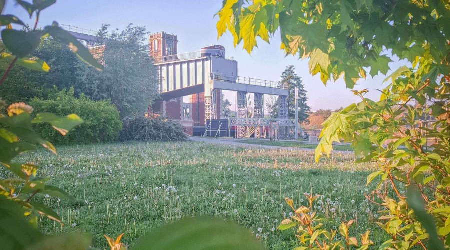
A Nature Trail Along the Water
Starting from the Fontinettes Boat Lift, enjoy a 9.4 km nature walk around Arques. Accessible to all, this trail combines forests, fields, and ponds — perfect for a family outing!
The Fontinettes Trail
Take a nature break around Arques with the Fontinettes Trail, an easy walk suitable for everyone and perfect for a family outing. This route takes you through fields, forests, bodies of water, and developed paths, inviting you to explore the region’s most beautiful natural landscapes.
Distance: 9.4 km
_detail
Error: Invalid Frontmatter
Path: /var/www/vhosts/ascenseurabateaux.com/httpdocs/user/pages/07.infos-pratiques/04.prolonger-votre-visite/11.randonnee-fontinettes-a-arques/03._detail/faq.en.md
Failed to read /var/www/vhosts/ascenseurabateaux.com/httpdocs/user/pages/07.infos-pratiques/04.prolonger-votre-visite/11.randonnee-fontinettes-a-arques/03._detail/faq.en.md: Unexpected characters near " principle.'" at line 5 (near "text: 'Start your walk at the Fontinettes Boat Lift, a 19th-century engineering marvel built in 1887. This mechanical monument once helped barges overcome a 13.13-meter drop using simple physics principles such as the Roberval balance and Archimedes' principle.'").
---
title: 'Key Stages of the Trail'
questions:
    -
        title: '1. Historic Departure'
        text: 'Start your walk at the Fontinettes Boat Lift, a 19th-century engineering marvel built in 1887. This mechanical monument once helped barges overcome a 13.13-meter drop using simple physics principles such as the Roberval balance and Archimedes' principle.'
    -
        title: '2. Canal and Towpath'
        text: 'Follow the towpath along the canal, then continue straight ahead on a specially developed path — perfect for a peaceful walk by the water.'
    -
        title: '3. Toward the Marina'
        text: 'At the end of the path, turn right after the bridge to reach Arques’ marina. Cross through to the pontoons, then turn right again at the end of the dock (pass through the gate).'
    -
        title: '4. Beauséjour Pond'
        text: 'Continue to the level crossing (use caution), turn left to walk along the railway line, and reach Beauséjour Pond — a former gravel quarry now loved by walkers and anglers.'
    -
        title: '5. Dike and Fork'
        text: "Follow the dike dividing the pond. At the end, two options await:\n\nShort route: Continue straight and turn left onto Rue Michelet toward the protected Malhôve Pond.\n\nLonger option (+1.2 km): Turn left toward the Arc-en-Ciel ponds, walk around them, return, and take Rue Michelet toward Malhôve Pond."
    -
        title: '6. Malhôve Pond'
        text: 'After passing through a small archway, Malhôve Pond reveals itself — a protected natural area rich in wildlife: frogs, dragonflies, herons, wild ducks, and graceful swans. Follow the path on the right side of the pond.'
    -
        title: '7. Toward the Forest'
        text: 'Take Rue de Montpellier and Rue de Bordeaux, then turn right after the stop sign onto a dirt road leading to Rihoult-Clairmarais Forest — a vast 1,200 ha woodland teeming with deer, wild boar, foxes, and rabbits.'
    -
        title: '8. Into the Woods'
        text: 'Follow the royal forest road, then take the right-hand path skirting the edge of the forest.'
    -
        title: '9. A Path through Memory'
        text: 'Turn right toward the level crossing, then follow Chemin de la Payelette and Rue Parmentier. Just after the gatekeeper’s house, look for traces of old German tracks used by civilians during WWII when Avenue Pierre Mendès France served as a landing strip.'
    -
        title: '10. Urban Crossing'
        text: "Turn left and carefully cross Avenue Pierre Mendès France at the pedestrian crossing.\n\nReturn via Rue Curie to reach the Boat Lift again, crossing the railway line through the small gate."
bouton_name: 'Download the Brochure'
bouton_url: 'https://ville-arques.fr/images/stories/images_tourisme/brochure_sdf.pdf'
---
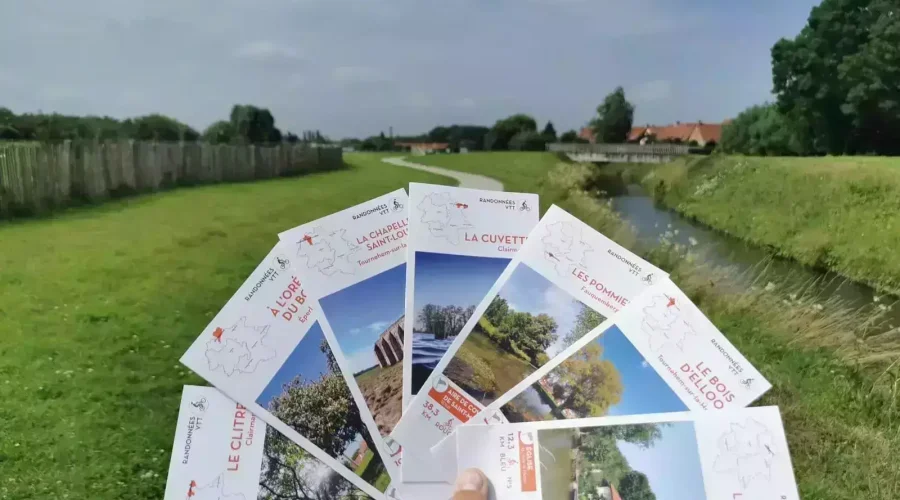
Ready for more adventure?
Whether on foot, by mountain bike or on horseback, the landscapes of the Saint-Omer and Lumbres areas are yours to explore. Forests, marshes, hills or country lanes — each route is an invitation to escape.
To plan your next outing, find all hiking trails available for free and in digital format on the website of the Saint-Omer Tourist Office and Convention Bureau.